VIDEO: “Big Lonely Doug,” Canada’s 2nd largest Douglas-fir tree!


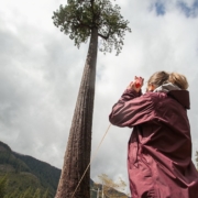
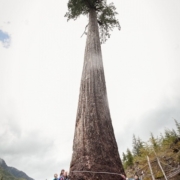
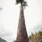
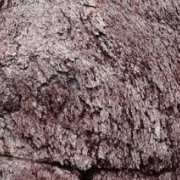
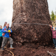
Port Renfrew, Vancouver Island, 2014 – “Big Lonely Doug,” a recently found old-growth Douglas-fir tree standing alone in a clearcut on southern Vancouver Island, has been officially measured to be the second largest Douglas-fir tree in Canada. Last week, renowned forest ecologist Andy MacKinnon, who manages the BC Big Tree Registry run by the University of British Columbia and is also the co-author of the best-selling “Plants of Coastal British Columbia, Washington, and Oregon,” measured the goliath tree.
Click here to watch on AFA’s YouTube channel.

For Immediate Release
April 24, 2014
“Big Lonely Doug” Officially Measured and Confirmed as Canada’s 2nd Largest Douglas-fir Tree
Port Renfrew, Vancouver Island – “Big Lonely Doug”, a recently found old-growth Douglas-fir tree standing alone in a clearcut on southern Vancouver Island, has been officially measured to be the second largest Douglas-fir tree in Canada. Last week, renowned forest ecologist Andy MacKinnon, who manages the BC Big Tree Registry (see: https://bigtrees.forestry.ubc.ca/) run by the University of British Columbia and is also the co-author of the best-selling “Plants of Coastal British Columbia, Washington, and Oregon”, measured the goliath tree. The results are as follows:
Big Lonely Doug dimensions:

  • Height: 70.2 meters or 230 feet
  • Circumference: 11.91 meters or 39 feet
  • Diameter: 3.91 meters or 12.4 feet
  • Canopy Spread: 18.33 meters or 60.1 feet
  • Total Points (“AFA Points” – American Forestry Association, NOT Ancient Forest Alliance!): 714.24 AFA points.

This makes Big Lonely Doug the second largest Douglas-fir tree in British Columbia and Canada in terms of total size, based on its “points” (ie. a combination of circumference, height, and crown spread) and the second largest in circumference. Big Lonely Doug was first noticed by Ancient Forest Alliance campaigner TJ Watt several months ago as being an unusually large tree, and the organization returned several weeks ago to take preliminary measurements. Official measurements were taken last Friday.
The world’s largest Douglas-fir tree is the Red Creek Fir, located just 20 kilometers to the east of Big Lonely Doug in the San Juan River Valley, and is 13.28 meters (44 feet) in circumference, 4.3 meters (14 feet) in diameter, 73.8 meters (242 feet) tall, and has 784 AFA points.
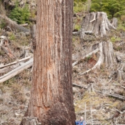
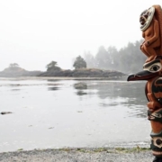
Conservationists estimate that Big Lonely Doug may be 1000 years old, judging by nearby 2 meter wide Douglas-fir stumps in the same clearcut with growth rings of 500 years. Big Lonely Doug grows in the Gordon River Valley near the coastal town of Port Renfrew on southern Vancouver Island, known as the “Tall Trees Capital” of Canada. It stands on Crown lands in Tree Farm Licence 46 in the traditional territory of the Pacheedaht First Nation band.
Conservationists are calling for provincial legislation to protect BC’s biggest trees, monumental groves, and endangered old-growth forests.
“We’re encouraging the province to keep moving forward with its promise to protect BC’s largest trees and monumental groves, and to also protect BC’s endangered old-growth ecosystems on a more comprehensive basis,” stated Ken Wu, AFA executive director. “The days of colossal trees like these are quickly coming to an end as the last unprotected lowland ancient forests in southern BC where giants like this grow are almost all gone.”
The BC Ministry of Forests, Lands, and Natural Resource Operations is currently working to follow up on a 2011 promise by then-Forest Minister Pat Bell to develop a new “legal tool” to protect the province’s biggest old-growth trees and grandest groves. Such a legal mechanism, if effective and if implemented to save not just individual trees but also the grandest groves, would be an important step forward in environmental protection and for enhancing the eco-tourism potential of the province. More comprehensive legislation would still be needed to protect the province’s old-growth ecosystems on a larger scale, to sustain biodiversity, clean water, and the climate, as the biggest trees and monumental groves are today a tiny fraction of the remaining old-growth forests which remain mainly on more marginal growing sites with smaller trees.
BC’s old-growth forests are important to sustain numerous species at risk that can’t live or flourish in second-growth stands; to mitigate climate change by storing over twice as much atmospheric carbon per hectare than the ensuing second-growth tree plantations that they are being replaced with; as fundamental pillars for BC’s multi-billion dollar tourism industry; to support clean water and wild salmon; and for many First Nations cultures who use ancient cedar trees for canoes, totems, long-houses, and numerous other items.
“The vast majority of BC’s remaining old-growth forests are at higher elevations, on rocky sites, and in bogs where the trees are much smaller and in many cases have low to no commercial value. It’s the productive valley-bottom stands where trees like the Big Lonely Doug grow that are incredibly scarce and are of the highest conservation priority right now,” stated TJ Watt.
See previous media coverage on Big Lonely Doug at:
• Global TV https://globalnews.ca/news/1235236/canadas-second-largest-douglas-fir-tree-may-have-been-found-near-port-renfrew
• Times Colonist https://www.timescolonist.com/news/local/vancouver-island-douglas-fir-may-be-canada-s-second-biggest-1.916676
• Vancouver Observer https://www.vancouverobserver.com/news/canadas-second-largest-douglas-fir-discovered
• CHEK TV https://www.cheknews.ca/?bckey=AQ~~,AAAA4mHNTzE~,ejlzBnGUUKY1gXVPwEwEepl35Y795rND&bclid=975107450001&bctid=3374339880001
• Huffington Post https://www.huffingtonpost.ca/2014/03/26/big-lonely-doug-tree_n_5038519.html?1395881730
• MetroNews [Original article no longer available]

Towering Vancouver Island tree officially second-largest in the country

As trees go, it is one colossal conifer.

Tape measures confirm that a Douglas fir tree on Vancouver Island is officially the second-largest in Canada.

According to the B.C. Big Tree Registry run by the University of British Columbia, the tree stands 70.2 metres high, about as tall as an 18-storey building. It has a diameter of 3.91 metres — almost as long as a mid-sized car.

Dubbed “Big Lonely Doug” by those who found it, it takes 11.91 metres of tape to wrap round the base of the enormous evergreen and at the top, the tree’s canopy spreads 18.33 metres across.

Conservationists believe the tree near Port Renfrew, on southern Vancouver Island, could be as much as 1,000 years old.

The country’s largest Douglas fir, located in the San Juan River Valley 20 kilometres east of Big Lonely Doug, stands 73.8 metres tall and has a circumference of 13.28 metres.

Environmentalists opposed to clear-cut logging are calling on the government to stop logging in old-growth forests like the ones where these towering trees are found.

Read more: https://www.theglobeandmail.com/news/british-columbia/towering-vancouver-island-tree-officially-second-largest-in-the-country/article18202501/

Check out Canada’s second largest Douglas-fir tree (photos)

That's one big tree.

Dubbed “Big Lonely Doug”, this Douglas-fir is the second largest tree of its species (Pseudotsuga menziesii) in Canada.

Forest ecologist Andy MacKinnon, who runs the B.C. Big Tree Registry, made it official last week, when he measured the thing.

Here's the stats:

Height: 70.2 metres or 230 feet
Circumference: 11.91 metres or 39 feet
Diameter: 3.91 metres or 12.4 feet
Canopy spread: 18.33 metres or 60.1 feet
Big Lonely Doug, found in the Gordon River valley on southern Vancouver Island, is estimated to be 1,000 years old.

The Ancient Forest Alliance, which sent out the photos, is calling for provincial legislation to protect big trees like this.

Read more: https://www.straight.com/blogra/633296/check-out-canadas-second-largest-douglas-fir-tree-photos

B.C.’s ‘Big Lonely Doug’ is the second-largest tree in Canada


PORT RENFREW — As trees go, it is one colossal conifer.

Tape measures confirm that a Douglas fir tree on Vancouver Island is officially the second-largest in Canada.

According to the B.C. Big Tree Registry run by the University of B.C., the tree — dubbed “Big Lonely Doug” by those who found it — stands 70.2 metres high, about as tall as an 18-storey building, and has a diameter almost that of a mid-sized car.

It takes 11.91 metres of tape to wrap round the base of the enormous evergreen and at the top, the tree’s canopy spreads across 18.33 metres.

Conservationists believe the tree near Port Renfrew, on southern Vancouver Island, could be as much as 1,000 years old.

The country’s largest Douglas fir, located in the San Juan River Valley 20 kilometres east of Big Lonely Doug, stands 73.8 metres tall and has a circumference of 13.28 metres.

Environmentalists opposed to clear-cut logging are calling on the government to stop logging in old-growth forests such as the ones where these towering trees are found.

Read more: https://www.theprovince.com/technology/Vancouver+Island+Lonely+Doug+second+largest+tree+Canada/9771718/story.html

Renowned forest ecologist Andy MacKinnon (left) stands with members of the AFA after measuring Big Lonely Doug.

Big Lonely Doug Officially Measured and Confirmed as Canada’s 2nd Largest Douglas-fir Tree

For Immediate Release

April 24, 2014

“Big Lonely Doug” Officially Measured and Confirmed as Canada’s 2nd Largest Douglas-fir Tree

Port Renfrew, Vancouver Island – “Big Lonely Doug”, a recently found old-growth Douglas-fir tree standing alone in a clearcut on southern Vancouver Island, has been officially measured to be the second largest Douglas-fir tree in Canada. Last week, renowned forest ecologist Andy MacKinnon, who manages the BC Big Tree Registry (see: https://bigtrees.forestry.ubc.ca/) run by the University of British Columbia and is also the co-author of the best-selling “Plants of Coastal British Columbia, Washington, and Oregon”, measured the goliath tree. The results are as follows:

Big Lonely Doug dimensions:

  • Height: 66 meters or 216 feet
  • Circumference: 11.91 meters or 39 feet
  • Diameter: 3.91 meters or 12.4 feet
  • Canopy Spread: 18.33 meters or 60.1 feet
  • Total Points (“AFA Points” – American Forestry Association, NOT Ancient Forest Alliance!): 701 AFA points.

This makes Big Lonely Doug the second largest Douglas-fir tree in British Columbia and Canada in terms of total size, based on its “points” (ie. a combination of circumference, height, and crown spread) and the second largest in circumference. Big Lonely Doug was first noticed by Ancient Forest Alliance campaigner TJ Watt several months ago as being an unusually large tree, and the organization returned several weeks ago to take preliminary measurements. Official measurements were taken last Friday.

The world’s largest Douglas-fir tree is the Red Creek Fir, located just 20 kilometers to the east of Big Lonely Doug in the San Juan River Valley, and is 13.28 meters (44 feet) in circumference, 4.3 meters (14 feet) in diameter, 73.8 meters (242 feet) tall, and has 784 AFA points.

Conservationists estimate that Big Lonely Doug may be 1000 years old, judging by nearby 2-meter-wide Douglas-fir stumps in the same clearcut with growth rings of 500 years. Big Lonely Doug grows in the Gordon River Valley near the coastal town of Port Renfrew on southern Vancouver Island, known as the “Tall Trees Capital” of Canada. It stands on Crown lands in Tree Farm Licence 46 in the traditional territory of the Pacheedaht First Nation band.

Conservationists are calling for provincial legislation to protect BC’s biggest trees, monumental groves, and endangered old-growth forests.

“We’re encouraging the province to keep moving forward with its promise to protect BC’s largest trees and monumental groves, and to also protect BC’s endangered old-growth ecosystems on a more comprehensive basis,” stated Ken Wu, AFA executive director. “The days of colossal trees like these are quickly coming to an end as the last unprotected lowland ancient forests in southern BC where giants like this grow are almost all gone.”

The BC Ministry of Forests, Lands, and Natural Resource Operations is currently working to follow up on a 2011 promise by then-Forest Minister Pat Bell to develop a new “legal tool” to protect the province’s biggest old-growth trees and grandest groves. Such a legal mechanism, if effective and if implemented to save not just individual trees but also the grandest groves, would be an important step forward in environmental protection and for enhancing the eco-tourism potential of the province. More comprehensive legislation would still be needed to protect the province’s old-growth ecosystems on a larger scale, to sustain biodiversity, clean water, and the climate, as the biggest trees and monumental groves are today a tiny fraction of the remaining old-growth forests which remain mainly on more marginal growing sites with smaller trees.

BC’s old-growth forests are important to sustain numerous species at risk that can’t live or flourish in second-growth stands; to mitigate climate change by storing over twice as much atmospheric carbon per hectare than the ensuing second-growth tree plantations that they are being replaced with; as fundamental pillars for BC’s multi-billion dollar tourism industry; to support clean water and wild salmon; and for many First Nations cultures who use ancient cedar trees for canoes, totems, long-houses, and numerous other items.

“The vast majority of BC’s remaining old-growth forests are at higher elevations, on rocky sites, and in bogs where the trees are much smaller and in many cases have low to no commercial value. It’s the productive valley-bottom stands where trees like the Big Lonely Doug grow that are incredibly scarce and are of the highest conservation priority right now,” stated TJ Watt.

See previous media coverage on Big Lonely Doug at:

• Global TV https://globalnews.ca/news/1235236/canadas-second-largest-douglas-fir-tree-may-have-been-found-near-port-renfrew
• Times Colonist https://www.timescolonist.com/news/local/vancouver-island-douglas-fir-may-be-canada-s-second-biggest-1.916676
• Vancouver Observer https://www.vancouverobserver.com/news/canadas-second-largest-douglas-fir-discovered
• CHEK TV https://www.cheknews.ca/?bckey=AQ~~,AAAA4mHNTzE~,ejlzBnGUUKY1gXVPwEwEepl35Y795rND&bclid=975107450001&bctid=3374339880001
• Huffington Post https://www.huffingtonpost.ca/2014/03/26/big-lonely-doug-tree_n_5038519.html?1395881730
• MetroNews https://metronews.ca/news/victoria/981658/photos-giant-douglas-fir-tree-found-in-b-c-may-be-largest-in-world/

Big Lonely Doug Officially 2nd-Largest Fir in Canada

PORT RENFREW, B.C. – As trees go, it is one colossal conifer.

Tape measures confirm that a Douglas fir tree on Vancouver Island is officially the second-largest in Canada.

According to the B.C. Big Tree Registry run by the University of British Columbia, the tree stands 70.2 metres high, about as tall as an 18-storey building. It has a diameter of 3.91 metres — almost as long as a mid-sized car.

Dubbed “Big Lonely Doug” by those who found it, it takes 11.91 metres of tape to wrap round the base of the enormous evergreen and at the top, the tree's canopy spreads 18.33 metres across.

Conservationists believe the tree near Port Renfrew, on southern Vancouver Island, could be as much as 1,000 years old.

The country's largest Douglas fir, located in the San Juan River Valley 20 kilometres east of Big Lonely Doug, stands 73.8 metres tall and has a circumference of 13.28 metres.

Environmentalists opposed to clear-cut logging are calling on the government to stop logging in old-growth forests like the ones where these towering trees are found.

Read more and view photos at: https://www.huffingtonpost.ca/2014/04/24/big-lonely-doug-second-largest-fir-canada_n_5206970.html?1398364327

Vancouver Island tree officially second-largest in Canada

PORT RENFREW, B.C. — As trees go, it is one colossal conifer.

Tape measures confirm that a Douglas fir tree on Vancouver Island is officially the second-largest in Canada.

According to the B.C. Big Tree Registry run by the University of British Columbia, the tree stands 70.2 metres high, about as tall as an 18-storey building. It has a diameter of 3.91 metres — almost as long as a mid-sized car.

Dubbed “Big Lonely Doug” by those who found it, it takes 11.91 metres of tape to wrap round the base of the enormous evergreen and at the top, the tree's canopy spreads 18.33 metres across.

Conservationists believe the tree near Port Renfrew, on southern Vancouver Island, could be as much as 1,000 years old.

The country's largest Douglas fir, located in the San Juan River Valley 20 kilometres east of Big Lonely Doug, stands 73.8 metres tall and has a circumference of 13.28 metres.

Environmentalists opposed to clear-cut logging are calling on the government to stop logging in old-growth forests like the ones where these towering trees are found.

Read more: https://www.ctvnews.ca/canada/vancouver-island-tree-officially-second-largest-in-canada-1.1790912

Earth Day Conservation Vision: Conservationists Propose Expanded Protection around World-Famous Cathedral Grove as Island Timberlands Poised to Log Mountainside Above Park

Conservationists call on BC government to expand protection around Cathedral Grove, including Mount Horne, the scenic Cameron Lake, the Alberni Summit Highway, and the Cameron River Canyon, as Island Timberlands is poised to log Mount Horne above the world-famous old-growth forest.

Port Alberni, Vancouver Island – Conservationists are calling on the BC government to expand protection around MacMillan Provincial Park to fully encompass the forests above and adjacent to the world-famous Cathedral Grove. Cathedral Grove is Canada’s most popular old-growth forest on Vancouver Island, visited by millions of tourists each year, and is found in the 301 hectare MacMillan Provincial Park. Island Timberlands has built a road through old-growth forests on Mt. Horne, the mountainside above Cathedral Grove, and could potentially commence logging soon of a new cutblock that could come as close as 300 meters away from the park boundary.

The preliminary conservation vision, that must still undergo consultation and refinement, would expand protection around the currently protected lands of 740 hectares (301 hectares in Macmillan Provincial Park and the adjoining 440 hectare Little Qualicum Falls Provincial Park) by an additional 2900 hectares. See a map of the vision at: https://16.52.162.165/photos-media/

The proposed expansion through a new provincial conservancy would include the old-growth forests, mature second-growth forests, and some recovering clearcuts around the parks, including:

Cathedral Grove’s surrounding forests: These are the forests on the mountainsides above MacMillan Park and the main highway, including Mount Horne which is threatened by Island Timberlands. See images of the Mount Horne forest at: https://16.52.162.165/photos-media/cathedral-grove-canyon/

Highway Scenic Buffer: Forests west of the existing park that currently buffer the main highway (Highway 4) up to the Port Alberni Summit (locally nick-named “The Hump”) to preserve the scenic viewshed of the drive from Cathedral Grove to Port Alberni (including the view for millions of tourists heading towards Tofino).

A year ago, local Port Alberni residents fought Island Timberlands from expanding a massive clearcut that would’ve marred the view along the highway, forcing the company to back off (see https://www.timescolonist.com/news/local/island-timberlands-logging-of-alberni-summit-could-denude-the-hump-1.50473). Now it’s time to secure final protection for the highway’s forested buffer.

Cathedral Grove Canyon: The spectacular old-growth forests and geological features of the area also known as the Cameron River Canyon, which should be a national treasure, were previously flagged for logging by Island Timberlands until a public outcry raised large-scale awareness. See photos at: https://16.52.162.165/protecting-old-growth-rainforests-to-the-economic-benefit-of-tourism-based-communities/4

Cameron Lake: Cameron Lake is a highly scenic lake that millions of tourists drive alongside on Highway 4 before reaching Cathedral Grove. The Crown lands on the north side of the lake should be protected, as only a narrow strip along the south side of the lake is currently protected.

The lands would be a combination of unprotected Crown lands (about 1000 hectares) and private lands owned by Island Timberlands (about 1900 hectares) that would require funds from the BC government, other levels of government, and possibly private land trusts for their purchase.

Logging the mountainside above the park would cause increased erosion and siltation into the park, destroy vital old-growth forest wildlife habitat, and ruin scenery and recreational opportunities on the Mount Horne Trail. See a map of the cutblock at www.SaveCathedralGrove.com

“The Horne Mountain block above Cathedral Grove is an area that the BC government’s own scientists consider to be of high conservation value. They worked for years trying to have protections placed on it. Despite environmental concern and public interest, professional foresters of Island Timberlands seem to be moving ahead with their harvesting plans – roads have now been constructed through this intact old growth forest and logging could start soon. Unfortunately, it is hard to imagine that logging on Mt. Horne's steep slopes above Cathedral Grove will have no negative effect on this iconic forest's health and longevity,” stated Jane Morden, coordinator of the Port Alberni Watershed-Forest Alliance.

“Of all places where the BC government needs to show environmental leadership it’s in Canada’s most famous old-growth forest, Cathedral Grove,” stated Annette Tanner, Chairwoman of the Mid-Island Chapter of the Western Canada Wilderness Committee. “The public shouldn’t bear the endless responsibility of safeguarding the park’s ecological integrity from the repeated onslaught of logging threats on adjacent mountainsides above Cathedral Grove. Will the BC government step forward and show leadership to safeguard the ecological integrity for this world-famous ancient forest and expand protection around it?”

“After the redwoods of California, Cathedral Grove is the best known old-growth forest on Earth. It should be a first rate priority for the BC government to stop any logging plans that threaten the park’s ecological integrity and ancient forest that millions of people visit,” stated Ken Wu, Ancient Forest Alliance executive director. “The BC government deregulated the environmental protections on this land in 2004 and failed to follow-through on an agreement that was supposed to protect the old-growth forests on those lands. They broke it, now they have a responsibility to fix it. The expansion of protected areas around Cathedral Grove, the scenic highway, Cameron Lake, and the Cathedral Grove Canyon will make this a world-class protected area, both ecologically and for tourism.”

“We need the BC government to re-establish a BC Park Acquisition Fund to purchase and protect endangered old-growth forests on private lands, starting with Cathedral Grove – or re-regulate them. In the meantime, Island Timberlands needs to back off if they have any environmental and community conscience,” stated TJ Watt, Ancient Forest Alliance campaigner and photographer.

More Background Info

Cathedral Grove is within the 301 hectare MacMillan Provincial Park, an area smaller than Vancouver’s Stanley Park, located along the Cameron River at the base of Mount Horne where the planned logging would occur. In 1997 the postage-stamp-sized park saw roughly 10% of its largest trees blow down in a winter storm, exacerbated by clearcutting near the park’s edge.

The protected areas expansion is a preliminary vision, still in development, being proposed by the Ancient Forest Alliance and local conservationists.

The new roads and planned logging will have numerous detrimental effects, including: fragmenting the continuous forest cover and wildlife habitat on the slope above Cathedral Grove; destroying some of the last remaining 1% of BC’s old-growth Douglas-fir trees on BC's coast; destroying the wintering habitat of black-tailed deer in an area previously proposed for protection by BC government scientists to sustain them; likely increasing siltation into the Cameron River (which runs through Cathedral Grove) during the heavy winter rains as soil washes down from a new clearcut and logging road; and destroying part of the Mount Horne Loop Trail, a popular hiking and mushroom-picking trail that the cutblock overlaps.

• See the Times Colonist article (March, 2013) on the discovery of the company’s logging plans: https://www.timescolonist.com/news/local/old-growth-near-cathedral-grove-set-for-imminent-logging-activists-1.90194

• See the CHEK TV clip (March 2013) about the original cutblock discovery: https://www.youtube.com/watch?v=3exaYAqSrzw

Until recently many of these threatened areas were regulated to the stronger standards found on public lands. However, in 2004, the BC Liberal government removed 88,000 hectares of Weyerhaeuser’s private forest lands, now owned by Island Timberlands, from their Tree Farm Licences, thereby not implementing the planned old-growth, scenic, wildlife, and endangered species habitat protections on those lands, and removing the existing riparian protections and restrictions on raw log exports. A follow-up agreement with the corporate landowners was supposed to see the protection of many of the deregulated old-growth forests (ie. proposed Ungulate Winter Ranges for elk and deer, and species-at-risk Wildlife Habitat Areas), but Island Timberlands and the BC Liberal government broke off negotiations several years ago and have failed to continue pursuing a solution. Alberni-Pacific Rim Member of the Legislative Assembly (MLA) Scott Fraser has repeatedly worked to hold the BC government to account to remedy the situation by getting Island Timberlands to hold-off from logging these hotspots until a political solution can be implemented.

The flagged cutblock on Mount Horne by Island Timberlands is estimated to be about 40 hectares and lies on the southwest facing slope of the mountain on the ridge above the park and highway that millions of tourists visit annually. The logging would take place in an area formerly intended by BC government biologists to become an Ungulate Winter Range to protect the old-growth winter habitat of black-tailed deer – a designation that never came to fruition when the BC Liberal government deregulated the lands in 2004 by removing them from their Tree Farm Licence. Mt. Horne and the Cathedral Grove area is in the territorial boundaries of the Hupacasath and Qualicum peoples.

Island Timberlands is currently engaged in multiple logging incursions into other highly endangered old-growth forests besides Mount Horne. This includes recent logging and/or road-building in Kwakiutl First Nations territory near Port Hardy; on McLaughlin Ridge, Juniper Ridge, Labour Day Lake, and the Cameron Valley Firebreak in the Port Alberni area (see: https://16.52.162.165/news-item.php?ID=678); plans to log the Stillwater Bluffs near Powell River and the Day Road Forest near Roberts Creek on the Sunshine Coast; and plans to log old-growth forests near Basil Creek and the Green Valley on Cortes Island. See spectacular PHOTOS of most of these forests at: https://16.52.162.165/photos-media/

Island Timberlands (IT) is the second largest private land owner in BC, owning 258,000 hectares of private land mainly on Vancouver Island, the Sunshine Coast, and Haida Gwaii. Conservationists are calling on Island Timberlands to immediately back-off from its logging plans in old-growth and high conservation value forests until these lands can be protected either through purchase or through regulation.

Conservationists are also calling for a provincial plan to protect the province’s old-growth forests, to ensure sustainable second-growth forestry, and to end the export of raw, unprocessed logs to foreign mills. For private lands, conservationists are calling on the BC Liberal government to re-establish and bolster the former BC park acquisition fund (eliminated after the 2008 provincial budget). A dedicated provincial fund of $40 million per year (about 0.1% of the $40 billion annual provincial budget), raising $400 million over 10 years, would go a long way towards purchasing and protecting old-growth forests and other endangered ecosystems on private lands across the province. The fund would be similar to the existing park acquisition funds of various regional districts in BC, such as the $3 million/year Land Acquisition Fund of the Capital Regional District around Greater Victoria, which are augmented by the fundraising efforts of private citizens and land trusts.

BC’s old-growth forests are vital to support endangered species, tourism, the climate, clean water, wild salmon, and many First Nations cultures whose unceded lands these are. About 75% of the original, productive old-growth forests have already been logged on BC’s southern coast, including over 90% of the valley-bottom ancient forests where the largest trees grow, and 99% of the old-growth Douglas fir trees on BC's coast. See maps and stats at: https://16.52.162.165/ancient-forests/before-after-old-growth-maps/

Tla-o-qui-aht, Tofino Celebrate Tribal park Declaration

Tofino — Tla-o-qui-aht First Nation celebrated the 30th anniversary of its declaration of a Tla-o-qui-aht Tribal Park on Meares Island with a gathering at Tofino Community Hall on April 20.

The 1984 declaration struck the first blow in a comprehensive fight to establish the right of First Nations people to protect their lands and resources, and by extension, those of their non-Native neighbours like Tofino. The April 21, 1984 declaration came about when monolithic logging giant MacMillan Bloedel (MB) announced plans to clearcut most of the forest cover on Meares Island, which is in the heart of Tla-o-qui-aht traditional territory.

While commemorating the efforts of those who launched and fought what was to become known worldwide as the War in the Woods, Tla-o-qui-aht used the occasion Sunday to extend the Tribal Park designation and its protections to cover its entire traditional territory.

Tla-o-qui-aht Beachkeeper Barney Williams Jr. greeted guests, who included many of the veterans, Native and non-Native, of the struggle. He explained that the concept of welcoming visitors is an important Nuu-chah-nulth tradition, but that it is implicit that visitors return that respect.

“For generations, our family has welcomed people over our beaches, and that tradition continues,” he said.

That welcome was freely extended to Europeans who arrived in the late 18th century, he noted. That they did not return that respect is a matter of history.

“We must remember that we’ve been here – and we’re still here,” he said. “We continue to extend the hand of friendship to those who come on our land.”

Moses Martin, current Tla-o-qui-aht chief councillor, was in 1984 the elected chief and living in Opitsat when the MB intentions were revealed.

“We met at Wickanninish School. It was Easter Sunday,” Martin recalled, adding that the gravity of the situation was obvious to all.

“I’ve spent a great deal of my time building relationships, and when you run up against something like that, it’s easy to get support from both First Nations and non-Native people. We had been working with the Friends of Clayoquot Sound, reviewing study after study of Meares Island.”

At the time, there were a lot of First Nations men working in the forest industry. It was well understood that a disruption in the industry would mean job losses for Tla-o-qui-aht members. Martin said even faced with that prospect, the loggers fully supported the new movement.

“Everybody was really on board, because the plan had 90 per cent of the island that was going to be logged,” he said. “We had seen that before, where whole mountains were clearcut. We didn’t want to see that here.”

Adding to the potential threat, Martin said, Meares Island is also the source of drinking water for Tofino. Clean drinking water flows from the island through an undersea siphon system. Unchecked logging would have destroyed the hydrology of the entire island.

In his address to the guests, Martin read off a long list of First Nations leaders, some, like the late Joe Mathias of Squamish First Nation, from across the country, who took part in the struggle, but are no longer living. The guests rose for an extended moment of silence to remember them.

“It was very easy to get that information out across the country,” Martin said. “We were able to get First Nations to come and support the work we were doing in Tofino.”

Guests also heard from some of the prominent non-Native stalwarts in the struggle, including Michael Mullin, who was on the front lines from the beginning.

“It has been an honour to be part of this, and to be in a place where people are proud of their place and look to their future and, with the leadership of the Tla-o-qui-aht, this was the first place in North America that people actually stood up to defend their land,” Mullin said.

“Meares Island was the first place where people turned back a logging crew, and the first time that people said, ‘This is our land, and we are going to assert our right to protect it.’ For that reason, Meares Island Tribal Park has been a leader and a model, not just for this country, but for the whole world.”

It was not just First Nations loggers who willingly gave up their livelihood to protect Meares Island. Lee Hilbert was an MB forestry engineer who realized he did not want to be complicit in the planned clearcut.

Hilbert was introduced by longtime friend and one-time logger Joe Martin.

“I was designing logging roads for MB,” Hilbert said. “I saw what was planned in this area in 1974, for the next 15 years, and it was going to be levelled.”

The plans he studied outlined a shocking progression of clearcuts across the entire countryside, including Meares Island, which, thanks to his friendship with Martin and his family, he knew to be considered sacred. It was then, he said, that he crossed the line from logging engineer to environmental activist.

“I quit the company. I found out where they were going to start, where the survey lines were. I called Joe and said, ‘You need to build a cabin right at Ground Zero,’ and he said I’d better talk to Moses.

“I called Moses and explained what I had in mind, to have a Native and non-Native community presence on the island, and he said, ‘I’ll be there and I’ll bring my boys.’”

Hilbert said by combining the energies of both the Native and non-Native communities, strengthened by traditional culture, what emerged was a “new tribe” dedicated to the preservation of Clayoquot Sound.

As MB finalized its plans for the Meares Island logging operation, the first protests took place in Tofino, then in Victoria. On the island where the road building was to begin, and where the log dump was to be located, people banded together to build a cabin to serve as a base camp.

Five months later, when the forest company sent in the first team of engineers and loggers to begin work in what they had officially dubbed Heel Boom Bay, they encountered a community unlike any previously assembled: people united to protect a pristine wilderness site.

In keeping with Nuu-chah-nulth tradition, Tla-o-qui-aht Chief Councillor Moses Martin welcomed the strangers onto the shore. But his words of greeting, which have now passed down into history, served notice that Nuu-chah-nulth lands and resources would be respected:

“You are welcome to come ashore and join us for a meal, but you have to leave your chainsaws in your boats. This is not a tree farm – this is Wah-nah-juss Hilth-hooiss, this is our Garden, this is a Tribal Park,” he told the MB delegation.

It was the beginning of an epic struggle that would eventually draw world attention to a small corner of the world known as Clayoquot Sound. The fight took place on the ground, in the woods, in the courts of law and in the court of public opinion.

The blockade lasted for five months. Then on March 27, 1985, the BC Court of Appeal ruled that there would be no logging on Meares Island until aboriginal land claims had been settled in the region.

At Sunday’s event, guests enjoyed an afternoon of traditional singing and dancing, including a song and dance that dates back to first contact.

Barney Williams explained that the song portrays how the first European visitors appeared, “On ships, surrounded by water. They had no land.” That snapshot of history has been preserved down to this day, he said.

Read more: https://www.hashilthsa.com/news/2014-04-22/tla-o-qui-aht-tofino-celebrate-tribal-park-declaration

First Tribal Park in BC/Indigenous Relations, Meares Island, Turns 30 Years Old and is Expanded

Vancouver Island, Canada

Yesterday, April 20th 2014, the 30 year anniversary of the Meares Island Tribal Park Declaration was celebrated by the Nuu-Chah-Nulth people of Clayoquot Sound on Vancouver Island along with their various friends and supporters, and a new Tribal Park declaration was made by Tla-o-qui-aht which effectively protects the rest of their territory including the resort municipality of Tofino.

The Meares Island Tribal Park was the first Tribal Park declared in British Columbia, and resulted in keeping the island’s majestic old-growth red-cedar forests still standing to this day. Since that time the Tribal Park model has not only been expanded by Tla-o-qui-aht in their own territory, but has also inspired First Nations’ protected areas across British Columbia and increasingly, around the world.

“The declaration of Meares Island as a Tribal Park 30 years ago set in motion an idea that has caught and spread throughout indigenous communities, that we can sustain our cultures by safeguarding the land and living things that provide for us,” stated Eli Enns, Tla-o-qui-aht co-founder of the Ha’uukmin (Kennedy Lake Watershed) Tribal Park in Clayoquot Sound. “We can assert our own management plans for our territories, as we have been doing for thousands of years, so that we can continue to live in harmony with the land that sustains us – and all of humanity.”

30 years ago, on April 21, 1984, the Tla-o-qui-aht and Ahousaht First Nations bands declared Meares Island as Canada’s first “Tribal Park” in a bid to stop logging plans of its old-growth forests. Protests were organized in Tofino, Victoria, and eventually on Meares Island in 1984, when the Tla-o-qui-aht and Ahousaht people were joined by non-First Nations allies at BC’s first logging blockade. The protests successfully fended off MacMillan Bloedel’s logging plans until March 27, 1985, when the BC Court of Appeal ruled that no logging could occur on Meares Island until aboriginal land claims had been settled in the region.
Tla-o-qui-aht First Nations

Recently, the declaration of the Tranquil Valley near Tofino as a Tribal Park has been making headlines in light of a proposed gold mine there, which the Tribal Park forbids. See: https://www.vancouversun.com/Vancouver+Island+First+Nation+declares+tribal+park+protect+land/9735029/story.html

“We have just finished a tribal park planning initiative that sustains jobs for 500 years, not just 10 years of jobs and 500 years of impact,” said Saya Masso, Tla-o-qui-aht band councillor and resource manager. “We are developing plans for our long-term future. We regard fish as a value, the serenity of our lands, and spiritual practices that we have to do there as all vital for our culture.”

Tla-o-qui-aht Tribal Parks are also increasingly being recognized as a model in the global conservation arena through the Indigenous Peoples’ and Community Conserved Territories and Areas (ICCA) consortium (see:https://www.iccaconsortium.org/), an international organization promoting indigenous peoples’ conservation areas across the globe. The ICCA recently brought indigenous conservationists and allied non-profit organizations together in Tofino Territory in November 2013, to gain insight from the Tla-o-qui-aht model of Tribal Parks and to assist in building networks of indigenous conservationists around the world promoting similar initiatives in their own territories.

“You are welcome to come ashore and join us for a meal; but you have to leave your chainsaws in your boats. This is not a tree farm – this is Wah-nah-juss Hilth-hooiss, this is our Garden, this is a Tribal Park.” declared Moses Martin respectfully on the front lines of the blockades in 1984. Thirty years later, in his same respectful manor, Moses spoke of the critical need to continue to work together, First Nations and non-first nations alike, to ensure a healthy environment and sustainable economy for everyone.

For more information contact:
Terry Dorward
Tribal Parks Manager
1-250-725-3350

Read more and view photos at: https://www.facebook.com/tlaoquiaht/photos/a.1427650360817434.1073741828.1427644927484644/1429096590672811/?type=1&theater